Hurricane Beryl, early and powerful: A precursor of what may come during 2024 hurricane season
As we write this, Hurricane Beryl is making its way through the Caribbean. It has already caused damage in the Windward Islands and made landfall on Grenada’s Carriacou Island on Monday, July 1 as a Category 4 storm. Beryl, the second named storm of the 2024 Atlantic hurricane season, follows Tropical Storm Alberto, which lashed the Gulf Coast of Texas with flooding rain and storm surge last month.
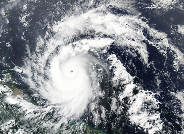
Hurricane Beryl’s intensity
Breaking records after intensifying to a Category 5 storm, Beryl is the most powerful storm to ever develop this early during the Atlantic hurricane season. And it’s likely a precursor to what’s to come. As it heads toward Jamaica and the Cayman Islands we are tracking its path with heightened concern. We know recovery from a hazard like Hurricane Beryl is particularly difficult in an island setting and is made worse by the marginalization of the people who live in these places.
What’s next?
Beryl is forecast to continue heading west/northwest over the next several days, with people in its path facing a long, drawn-out devastation. It should reach the Yucatan Peninsula of Mexico by the end of the week, an area that was just affected by Tropical Storm Chris, dropping flooding rains, increasing the risk of mudslides and more.
Models now show a chance for a significant impact on Texas over the weekend as Beryl turns north once it hits the warm waters of the Gulf of Mexico. Any community in its potential path must be prepared and ready to evacuate or shelter in place as directed.
Beryl is the first of several large storms expected to form and have an impact in the Atlantic this season. NOAA and other scientific forecasters are predicting an above-normal season this year. Beryl’s early arrival confirms their analysis as ocean waters are very warm and the atmosphere is ripe for fueling intense storms. There is another storm, Invest 96L, that is expected to become a tropical depression over the next few days and take a similar path to the one that Beryl is on.
What can we do?
As this powerful storm makes its way through the Caribbean and into the Gulf, we at CDP will continue to monitor its impact on islands and countries in its path. And we’ll continue watching as this potentially heightened hurricane season continues. Here are some ideas for how you can help:
- Understand the unique needs of islands that are affected by hazards like hurricanes. Recovery from disaster is a long process in any setting, but it’s particularly complex on an island.
- Learn more about the effects of hurricanes, cyclones and typhoons and how communities can be better prepared and recover more equitably through CDP’s Issue Insight.
- Support the CDP Atlantic Hurricane Season Recovery Fund to help affected communities recover equitably from storms that impact them.
Our fund management team stands ready to help any community affected by storms this year. If you have any questions about the Atlantic hurricane season or the effects of these storms on fragile communities, please reach out to Sally Ray, Director of Domestic Funds, at sally.ray@disasterphilanthropy.org or Alex Gray, Director of International Funds, at alex.gray@disasterphilanthropy.org.